Thursday, July 15, 2010

The Royal Gorge, Canon City, Colorado


A few years ago Shelley's brother Tom treated Monte and Shelley to a train ride that follows the Arkansas River through the bottom of the Royal Gorge. This year Shelley and Monte were visiting some of Shelley's family in Canon City and we decided to do the attractions above the Royal Gorge. We were joined by Shelley's cousins Cheryl, Deanna, Michaela, and Katie.


The first thing we did was to ride the Incline Railway to the bottom of the gorge (and back up). The railway is 1,550' long and is at a 45 degree angle. The important point here is that it has 19 manually operated stopping devices and an automatic governor that will stop the cars in an emergency.

Next we walked across the gorge via The Royal Gorge Bridge which is the world's highest suspension bridge. Bridge construction was started in June 1929 and completed in October of that year. It is 1,053' above the Arkansas River, 18' wide, the towers are 150' high and will support in excess of 2 million pounds. Original cost to build the bridge was $350,000. Today's cost would be over $15 million. Although we walked across, driving across is allowed.


Since we walked across one way we rode back across the chasm on the Aerial Tram. It is the World's longest single-span aerial tram. It is 2,200' long and 1,178' above the river and was built in 1968. It was pretty windy but once in the car we did not notice the wind swaying the car as we thought we would.

 Now, I think I promised pole dancing in this blog so here it is.   Shelley pole dancing on the Antique Replica Carousel (shouldn't that be Replica Antique?).

Last was the Silver Rock Railroad. Quite the scenic railway.

A good time was had by all.  And another to do is scratched off of our bucket list.

Sunday, July 11, 2010

A Visit in Salida or "I Must Have Bats In My Belfry"

We stopped for a few days in Salida, Colorado to visit Shelley's cousin Omar and his wife Anne. Omar and Anne have recently moved into a house that is located at a campground that Omar owns. So, it was extremely convenient as they reserved us the camping site closest to their home.

On our second day there they announced that they thought it would be nice if we all went to the Orient Land Trust (OLT) that evening to see a huge colony of Mexican Free Tailed Bats leave their roost and head out on their nightly hunt. We thought it sounded like a pretty cool thing to do and said sure we would go. Omar then explained that after we arrived at the land trust, the trip would entail a short hike to see the bats. “No problem” thought I. They also vaguely alluded to the fact that the OLT was the home of clothing optional hot springs. So – I'm thinking – “I'm going to see bats not naked people at a hot springs – and Anne and Omar are not clothing optional type people so - it'll be okay.”
Now for some background. First of all,Omar and Anne live at 8,000 feet above sea level. Our house in Florida is 38 feet above sea level. So already they are way way ahead of us as they are used to oxygen deprivation. Second, Omar is Mr. Mountain Man. He has climbed each of Colorado's 54 mountains that are over 14,000 feet and many of them multiple times. Anne is no slouch either and has climbed her share of mountains also.

We get to the OLT and find out that this little hike is 1.8 miles and we are currently at 8,600' and will climb 800' in elevation to 9,400' (9,425 to be exact). OMG, I'm old, over-weight, out of shape, can't breath as it is, and here we go. And I'm thinking “I must be batty to be doing this”

We head off to meet our tour guide, Roger. I'm sorry that I failed to take a picture of Roger so you will just have to use your imagination. Roger is probably 50 years old and looks to be in quite good shape. We can tell this by the clothes or lack there of that he is wearing. Roger has on Army issue boots and white socks, a green Army t-shirt that the tail of just barely manages to cover his butt and a 45 pound pack on his back (I know it was 45 lbs because he told us repeatedly that it was 45 lbs) and that is ALL. Roger is standing there tugging on the tail of his t-shirt trying to cover – well, those parts that should be covered.  As we head out on our little walk, we see other folks that are staying at OLT (it is a resort) and thankfully they all have the decency to be adequately dressed. (I know, I'm such a prude).

The hike took 1.5 hours, we did have many rest stops, not enough but many and although I brought up the rear the entire time and bitched and moaned and thought that my lungs would burst or if not them my heart – but I made it. On the way up we learned special tidbits of information from Roger. Such as – did you know that rodents are not mammals? Or did you know that a jackass is the result of the mating of a donkey and a mule? You get the picture – Roger is one of these people that thinks he knows everything but in reality knows absolutely nothing.

About 10 minutes after we got to the Glory Hole where the bats were to come out of – out they came. In waves, all 200,000 or 250,000 of them. This is kind of a strange bunch because it is 100% bachelors. All the girls and kids are at Carlsbad Caverns in New Mexico. Or so Roger said. After about 20 minutes of bat watching it was the hike back down which only took 50 minutes.


We had fun and it was interesting and I'm glad we went. However, Omar and Anne, next time you plan an excursion I'm going to Google it first and see what the real scoop is so that I know whether or not I need to pack an oxygen bottle.

One last note – on the way back the path had been very dark and Monte and Omar were wearing headlamp type flashlights to light our way. When we got back to the bottom we all needed to use the restroom. Turned out that they are all unisex but at least the stalls had doors which was more than we could say for the urinals. As Monte was waiting outside the bathroom his headlamp was still on and he heard footsteps and turned around and there, like a deer in the headlights, was some woman in all her glory, carrying just her towel to the shower. Monte said it was not a pretty sight and he really wanted to offer her his jacket as she could really use a coverup – but she was completely oblivious to his discomfort and her own case of the sags and bags and just strolled right on by him.

Wednesday, July 7, 2010

Independence Day Weekend

We arrived in Centennial, Colorado on Friday July 2nd to spend the weekend and celebrate Independence Day with life-long friends Jerry Williams (who lives in Oklahoma City), her daughter Barbie and Barbie's husband Chris. 

On Saturday Jerry, Barbie, Monte and Shelley headed out with high hopes and full pockets en route to Colorado's gambling mecca, Black Hawk. We were a happy bunch on the way up through the mountains – the weather was perfect, the views spectacular and there was no traffic to fight. Four or so hours later our pockets were certainly no longer full, more like someone had cut a large hole in each of our pockets and the cash had poured out. However, we were still a happy bunch. On our way back down the mountain we got happier in that we had gone early in the day as the traffic on the Interstate that was headed up the mountain was backed up for no less than 10 miles – seriously 10 miles.

Sunday was Independence Day. We were joined for a 4th cookout by Shelley's brother Tom who lives just northeast of Denver. It rained most of the afternoon but the rain stopped just in time to get the steaks on the grill and cooked to perfection.  Dinner was great, and the company greater. Shortly after getting the steaks off of the grill the skies opened up again and it rained for several more hours.  We watched the Boston Pops concert and the $2 million dollar fireworks show from Boston on TV to finish off the day.  It is so wonderful to be able to visit with friends and family during our travels. And to do it on Independence Day makes it even more special. What a great country the USA is.

Thanks Barbie and Chris for the hospitality. Jerry – we'll see you again in OKC. Tom – I hope you get a chance to come to our house soon (after we get back home would be nice).

Tuesday, July 6, 2010

A Stop at a Roadside Restaurant

So, the other day during one of our day trips Monte and I stopped for lunch at a roadside restaurant. After we finished eating we got back in the car and on down the road we went.

About 40 minutes later I needed to look at a map and realized that I had left my glasses at the restaurant. You can imagine how happy Monte was when I told him we had to go back. All the way back Monte was the classic grouchy old man. He fussed, fumed, complained and huffed and puffed. He did eventually shut up but the scowl and glares were enough to freeze the rain that was hitting the windshield.

We finally got back to the restaurant and as I got out of the car and was hurrying inside I heard Monte yell at me “While you are in there you might as well get my hat and the credit card.”

Monday, July 5, 2010

The Snowy Range, Laramie, Wyoming

One of the day trips we took while in Cheyenne was along the Snowy Range Road. The Snowy Range is a mountain range within the Rocky Mountains.

The Snowy Range Road runs from Laramie, Wyoming to the Upper Platte River Valley and was designated the Second National Forest Scenic Byway in the United States. Started in 1920, it took 6 years to complete and was called the “Great Skyroad”. The byway runs through the heart of the Medicine Bow National Forest and even though we were there at the beginning of July, there was still an abundance of snow and most of the pull-offs and picnic areas were inaccessible due to snow. We found the this range of the Rocky Mountains to be spectacular. The stunning views of jagged gray granite peaks and beautiful blue lakes make this area very special.

Enough said – I'll let the pictures speak for themselves.


Cheyenne and Warren Air Force Base


Spent a few days camped at Warren Air Force Base in Cheyenne, WY.


It is a beautiful base, old red brick buildings and lots of green spaces and evergreen trees. Just a really nice place. This was enhanced by the wildlife on base. Everyday pronghorn antelope wander through the campground, lots of prairie dogs squeaking and whistling warnings as I walked the dogs, a large flock of Canada Geese, an abundance of cute little cotton tail rabbits. All of these critters added to our enjoyment.

Warren AFB is home to the 90th Missile Wing and is responsible for 150 Minuteman III ICBMs. As much as we enjoy staying on military bases,and appreciate the privilege of being allowed to camp on base, it is so nice to just be visiting and no longer part of the active duty force. This is brought home to me when we see hoards of troops out for 3 days in a row practicing for a major retirement and change of command – so major that the Vice President was to be in attendance – so you can imagine that everything had to be perfect. The commander of the Twentieth Air Force, the person responsible for all of the nation's ICBM force was ending his 36 years of service. So glad to not have to sweat the load over that kind of stuff anymore.


We spent sometime touring Cheyenne, the capitol of Wyoming. I guess the most interesting thing we found was their Big Boots.


If we had been a couple of weeks later we would have been in Cheyenne for Frontier Days – maybe next time.

Saturday, July 3, 2010

Ft. Laramie, Wyoming

Our next stop was only about 100 miles away - there is so much history in this area there is no way to stop and see each museum, old fort, trading post.  However, we felt that this was an important stop to include.

Fort Laramie, the military post, was founded in 1849 when the army purchased the old Fort John for $4000, and began to build a military outpost along the Oregon Trail.


For many years, the Plains Indians and the travelers along the Oregon Trail had coexisted peacefully. As the numbers of emigrants increased, however, tensions between the two cultures began to develop. To help insure the safety of the travelers, Congress approved the establishment of forts along the Oregon Trail and a special regiment of Mounted Riflemen to man them. Fort Laramie was the second of these forts to be established.

The popular view of a western fort, perhaps generated by Hollywood movies, is that of an enclosure surrounded by a wall or stockade. Fort Laramie, however, was never enclosed by a wall. Initial plans for the fort included a wooden fence or a thick structure of rubble, nine feet high, that enclosed an area 550 feet by 650 feet. Because of the high costs involved, however, the wall was never built. Fort Laramie was always an open fort that depended upon its location and its garrison of troops for security.


In the 1850s, one of the main functions of the troops stationed at the fort was patrolling and maintaining the security of a lengthy stretch of the Oregon Trail. This was a difficult task because of the small size of the garrison and the vast distances involved. In 1851, the Treaty of 1851 was signed between the United States and the most important tribes of the Plains Indians. The peace that it inaugurated, however, lasted only three years. In 1854, an incident involving a passing wagon train precipitated the Grattan Fight in which an officer, an interpreter, and 29 soldiers from Fort Laramie were killed. This incident was one of several that ignited the flames of a conflict between the United States and the Plains Indians that would not be resolved until the end of the 1870s.

The 1860s brought a different type of soldier to Fort Laramie. After the beginning of the Civil War, most regular army troops were withdrawn to the East to participate in that conflict, and the fort was garrisoned by state volunteer regiments, such as the Seventh Iowa and the Eleventh Ohio. The stream of emigrants along the Oregon trial began to diminish, but the completion of the transcontinental telegraph line in 1861 brought a new responsibility to the soldiers. Inspecting, defending, and repairing the "talking wire" was added to their duties. During the latter part of the 1860s, troops from Fort Laramie were involved in supplying and reinforcing the forts along the Bozeman Trail, until the Treaty of 1868 was signed.

Unfortunately, the Treaty of 1868 did not end the conflict between the United States and the Plains Indians and, by the 1870's, major campaigns were being mounted against the plains tribes. The discovery of gold in the Black Hills, in 1874, and the resultant rush to the gold fields had violated some of the terms of the treaty and antagonized the Sioux who regarded the Hills as sacred ground. Under leaders such as Crazy Horse and Sitting Bull, they and their allies chose to fight to keep their land. In campaigns such as the ones in 1876, Fort Laramie served as a staging area for troops, a communications and logistical center, and a command post.


Conflicts with the Indians on the Northern Plains had abated by the 1880s. Relieved of some of its military function, Fort Laramie relaxed into a Victorian era of relative comfort. Boardwalks were built in front of officers' houses and trees were planted to soften the stark landscape.

By the end of the 1880s, the Army recognized that Fort Laramie had served its purpose. Many important events on the Northern Plains had involved the Fort, and many arteries of transport and communication had passed through it. Perhaps the most important artery, however, the Union Pacific Railroad, had bypassed it to the South. In March of 1890, troops marched out of Fort Laramie for the last time. The land and buildings that comprised the Fort were sold at auction to civilians.

Chadron, Nebraska

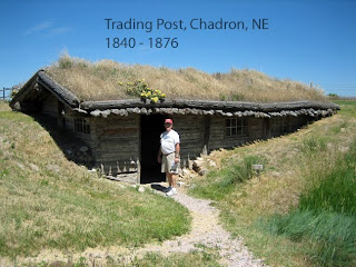
Heading north from Alliance, NE we stopped for the night in Chadron, NE. Why Chadron you ask? Simply to go to the Museum of the Fur Trade.

The Museum of the Fur Trade is located at the site of James Bordeaux's trading post. The trading post was established in 1837 by the American Fur Company. The company had just purchased Ft. Laramie, a hundred miles away and they planned to maximize their trade in prime buffalo robes by establishing posts in the protected valleys where the Indians wintered. Bordeaux prospered until after the Civil War when conditions on the Northern Plains were unsettled and the trade was often that of supplying contraband arms to Indians who were resisting efforts to force them onto reservations.

Bordeaux abandoned the post in 1872 and it was taken over by Francis Boucher, son-in-law of Spotted Tail, head chief of the Brule Sioux. Boucher's main interest was smuggling arms and ammunition to the Indian warriors fighting against the army. Undoubtedly, gunds and cartridges from his post figured in the defeat of General Custer. When the Army caught Boucher with 40,000 rounds of ammunition in 1876 they put him out of business.

The Museum traces the everyday lives of British, French, and Spanish traders, voyageurs, mountain men, buffalo hunters and the Plains and Woodland Indians. This small, privately funded museum is very well done and we glad we made the stop.


Remember those miles and miles of coal trains that I mentioned in an earlier post? Well, we found out what campground they all travel past. I guess our first hint should have been when the ad in the campground book said “If you love trains, this is the campground for you.” During the afternoon empty trains were rolling steadily past headed west. Along about sundown the fully loaded trains coming from Wyoming started rolling by, one after another, after another, after another. It was not that the trains were passing by but the fact that about 100 yards away was a RR crossing and so they have to blow their whistle, multiple times. There was more than once that I was sure a train was going to join us in bed.


WESTWARD HO!!

Monday, June 28, 2010

Carhenge, Alliance, Nebraska

At the far western edge of Nebraska's Sand Hills is the town of Alliance.  The Sand Hills end very abruptly here and Alliance's only (to my knowledge) claim to fame is as the home of Carhenge.

Carhenge is a replica of England's Stonehenge. Carhenge is formed from vintage American cars all covered with gray spray paint. There are 38 cars arranged in a circle measuring about 95' in diameter. Some are held upright in pits and other form arches by the cars having been welded atop the supporting models. Carhenge replicates Stonegenge's current tumble-down state.


We can scratch this one off of our bucket list.

The Sand Hills of Nebraska

Heading west out of Omaha we could have driven the 450 miles of I-80 to get to the western edge of Nebraska. However, since we had driven that boring route before, when we got to Grand Island we decided to detour and take Hwy 2 through the Sand Hills of Nebraska.

We had no idea what to expect of the Sand Hills. We found that they sure don't look anything like what we expected to see in Nebraska.

About a quarter of Nebraska is covered by the Sand Hills, so called because the hills are entirely made of - now let's not always see the same hands - sand. The Sand Hills are Pleistocene sand dunes derived from glacial outwash eroded from the Rockies, and now (mostly) stabilized by vegetation.

Dunes in the Sand Hills may exceed 330' in height. The average elevation of the Sand Hills region gradually increases from about 1,800' in the east to about 3,600'in the west.

As much as 85% of the Sand Hills region is intact natural habitat, the highest level in the Great Plains. This is chiefly due to the lack of crop production: most of the Sand Hills land has never been plowed. The plant-anchored dunes of the Sand Hills were long considered an irreclaimable desert. In the 1870s, cattlemen began to discover their potential as rangeland for longhorn cattle

The fragility of the sandy soil makes the area unsuitable for cultivation of crops. Unsuccessful attempts at farming were made in the Sand Hills region in the late 1870s and again around 1890.

Today, the Sand Hills are a productive cattle ranching area, supporting over 530,000 beef cattle. The population of the region continues to decline as older generations die out and as younger generations move to the cities.

As the largest and most intricate wetland ecosystem in the United States, the Sand Hills contain a large array of plant and animal life. Minimal crop production has led to limited land fragmentation; the resulting extensive and continuous habitat for plant and animal species has largely preserved the biodiversity of the area.


The Sand Hills are home to 314 animal species including mule deer, coyotes, red fox, meadowlarks, wild turkeys, native bat species and many fish species.

720 different species of plants are found in the Sand Hills. Of these, the majority are native, with only 7% exotics — half the percentage of most other prairie systems

Many of the plants of the Sand Hills are sand-tolerant species from short-grass, mixed-grass and tallgrass prairies; plants from all three of these can be found within the Sand Hills ecosystem. These plants have helped to stabilize the sand dunes, creating an ecosystem beneficial for other plants and animals. Better land management and grazing practices by the ranchers of the Sand Hills have led to less erosion over time, which has kept the natural landscape of the Sand Hills mostly intact.

The Sand Hills are part of the central flyway for many species of migratory birds, and the region's many bodies of water give them places to rest. The ponds and lakes of the region are lay-over points for migratory cranes, geese, and many species of ducks.

Most of the Sand Hills receives less than 20 inches of rain annually leading to the classification of the area as a semi-arid region. Plant and animal species of the Sand Hills region have adapted to the area's climatic extremes, which include 100°F summer days and -30°F winters.

If you like long trains, Nebraska Route 2 is a place to see them. They are carrying coal from Wyoming, and 140 cars is not unusual.


Thanks to Wikipedia for much of the foregoing information.